Saildrone, in collaboration with the U.S. Department of Commerce’s NOAA (National Oceanic and Atmospheric Administration), is sending two uncrewed surface vehicles (USVs) into the Gulf of Mexico to collect data in two areas currently experiencing buoy outages, to ensure the flow of ocean data continues uninterrupted for weather forecasting.
According to Saildrone, access to ocean data has never been more critical, with life-threatening heat waves experienced around the globe and the U.S. hurricane season in full swing. The ocean environment is a key driver of weather patterns on land, so the insights gained there can improve the understanding of changing climate and its impact on humanity.
The NOAA National Data Buoy Center (NDBC) has over 200 moored weather buoys collecting ocean data around the globe. Maintaining and repairing the network of buoys and their sensors is a big job that requires experts to travel on ships for weeks at a time far from shore.
Two weather buoys in the middle of the Gulf of Mexico are slated for repair in the coming weeks. Until they are back online, Saildrone USVs began collecting and sending ocean data to the NDBC, which will be shared with climatologists and weather forecasters around the world via the Global Telecommunication System (GTS).
“These two stations in the central Gulf of Mexico, 42001 and 42003, have operated in the same locations for almost fifty years, providing a critical long-term climatology record of atmospheric and oceanographic conditions,” said William Burnett, Ph.D., Director of NOAA’s National Data Buoy Center. “At times when these deep-ocean stations stop reporting, the ability to quickly send uncrewed vessels to mitigate the outage until we can service the platforms is essential. Saildrone has been partnering with us to explore new ways to leverage technology to collect this data in a safe and sustainable manner.”
The ocean covers 70% of the earth’s surface, so climatologists use the limited ocean observations they can obtain to estimate measurements for near and long-term global weather forecasts. These forecasts serve many purposes, ranging from ocean conditions and hurricane predictions to maritime safety for the shipping industry. The latter transports 80% of goods around the globe, providing jobs for almost 650,000 people in the U.S., and $150 billion in annual economic output.
“NDBC performs a critical role in the monitoring and prediction of global weather patterns,” said Matt Womble, Saildrone Director of Ocean Data Programs. “We are excited to be taking part in this mission and look forward to demonstrating the value Saildrone can bring to the sustainable collection of more ocean data in the future.”
Alameda, CA-headquartered Saildrone’s patented wing technology was born from research and development done by Founder & CEO Richard Jenkins. He developed the company’s core technology during a 10-year effort to break the land-speed record for wind-powered vehicles, which he achieved in 2009 in Nevada, with a speed of 126.2 mph. He then moved to San Francisco and began to apply his now-patented wing technology to USVs capable of collecting high-resolution data in the most remote areas of the ocean.
The capabilities of Saildrone USVs enable quick mitigation of outages within moored buoy networks, particularly in more remote areas of the ocean, and dramatically increase observations in large data sparse regions of the ocean. They can sail to regions that are not instrumented, stay on location for up to a year, and then return to port for maintenance and sensor calibration. This eliminates the need for large, crewed ships to travel hundreds of miles into remote or dangerous waters, both improving maritime safety and decreasing costs associated with additional ocean data collection.
The capabilities of Saildrone’s autonomous vehicles have been proven in numerous operational missions for science, ocean mapping, and maritime security—covering 800,000+ nautical miles from the Arctic to the Antarctic. The Saildrone fleet has logged 18,000+ days at sea in some of the most extreme weather conditions on the planet.
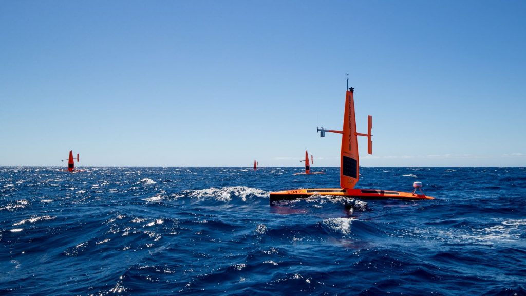
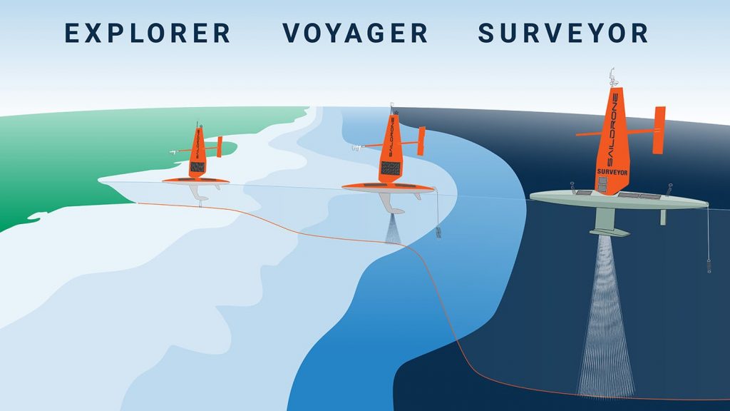
The Saildrone Explorer is a 23 ft (7 m) long, 15 ft (5 m) tall, and 6 ft (2 m) draft wind- and solar-powered USV designed to collect high-resolution ocean data in remote areas of the ocean while creating a zero-carbon footprint. The USVs are deployed and recovered from any oceanside dock and are designed to fit into a shipping container for transit to any launch site. Once launched, they can make their own way to the area of study, returning to port at the end of the mission.
Sailing at an average speed of up to 3 knots, the Explorer carries a suite of scientific sensors for the collection of ocean data. Payload options include a broad array of sensors for parameters like wind speed and direction by Gill Windmaster 3D ultrasonic, air temp and humidity via Rotronic HC2 – S3, and barometric pressure by Vaisala Barocap PTB210. Wave height and period are measured by dual GPS-aided IMUs (inertial measurement units). Its smart camera array is by 360-degree high-resolution optical cameras with ML (machine learning) target detection. Bathymetry can be measured by sensors like a shallow-water single-beam (Airmar DT800) or by deep-water single-beam units (Teledyne Echotrac E20 and Simrad WBT Mini).